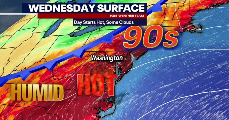
A cold front pushing in from the west could trigger a few strong to severe storms across the Washington area late Tuesday, with the main threat coming from damaging wind gusts and hail. A severe thunderstorm watch remained in effect from the D.C. metro to areas along the Pennsylvania state line until 7 p.m.
The risk for damaging wind gusts up to 70 mph and hail had increased, and the best chance for severe weather was focused along and north of I-66. Locally heavy rainfall and lightning were also forecast, with the main window to watch running from late afternoon through the evening.
Before the storms arrive, temperatures were expected to climb into the middle 90s, adding another layer of stress to a day already turning hot fast. For readers tracking dc weather, the setup is the kind that can flip quickly: oppressive heat in the afternoon, then storms strong enough to bring down branches and scatter commuters by nightfall. A short summary of the day’s forecast, including the heat peak and a cooler weekend outlook, was also available in this update: Washington Dc Weather: Heat peaks at 97 before storms and cooler weekend.
The front is also setting up a sharp change for the rest of the week. Temperatures were expected to tumble more than 25 degrees by the end of the week, with some communities staying in the 50s on Friday and Saturday. Memorial Day weekend was expected to begin Friday with steady rain showers, cool air and onshore flow, followed by clouds, occasional showers and areas of drizzle Saturday as highs struggled through the 60s.
Sunday was not expected to be a washout, but scattered showers were forecast to linger through the day. Memorial Day was trending toward gradual improvement, with more dry time and only a lingering chance for a shower, especially during the first half of the day. Winds were expected to ease to 5 to 10 mph Friday and around 5 mph at times later in the holiday stretch, but the bigger story is that the region is moving from a dangerous heat-and-storm setup into a cool, wet start to the long weekend.
For the D.C. metro and the broader Mid-Atlantic coast, that means outdoor plans are now at the mercy of a front that can deliver severe weather first and a chilly, unsettled holiday weekend right after.