Chicago-area residents are heading into a warm, unsettled stretch that will bring periodic chances for showers and thunderstorms through early next week. Friday evening stayed mild, with temperatures in the upper 60s under clear skies and southerly winds around 14 mph.
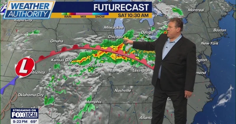
A line of showers and thunderstorms developing over Iowa is expected to move into northern Illinois late overnight into early Saturday morning, with the strongest storms capable of gusty winds and hail, especially west of Chicago and around sunrise Saturday. Most areas should get at least some rainfall before conditions dry out later Saturday morning, but the weekend is not expected to be a washout. Scattered showers and thunderstorms are expected mainly during the evening and overnight hours Saturday and Sunday, while daytime conditions stay partly sunny and largely dry.

The warmth is likely to hold through Tuesday, with highs climbing into the low- to mid-80s and some areas possibly reaching the upper 80s over the weekend. Another round of potentially strong thunderstorms is possible Monday, followed by lingering showers Tuesday before a cold front brings cooler temperatures by midweek.
That change should reset the region to more seasonal weather Wednesday through Friday, when highs are expected in the upper 60s to low 70s and drier conditions are forecast to settle in for the latter half of the week. The pattern is less a single storm and more a stretch of summerlike warmth interrupted by repeated rounds of rain, with the cold front marking the end of the warm run.