Rain chances are climbing across Central Florida on Wednesday as moisture keeps building, and the first showers were already popping up along the coast before the day fully got going. By afternoon, the best shot for rain and storms was expected west of Orlando, where colliding sea breeze boundaries could set off heavier downpours.
Julie Broughton said the area west of Orlando had the highest rain and storm coverage Wednesday afternoon, with rain chances there running about 40% to 50%. That matters now because the change is happening in real time: the region is moving from a few early showers to a more active pattern that will shape commutes, outdoor plans and the feel of the rest of the week.
The forecast calls for highs in the upper 80s along the coast and the low 90s inland Wednesday, but the bigger shift comes Thursday and Friday as moisture continues to build. Rain and storm chances are expected to rise each day, coverage should spread across much of Central Florida by Friday, and afternoon highs are expected to reach the low to mid-90s late in the week.
That combination is what makes the setup more than a routine rainy season pattern. Even without widespread severe weather, a few stronger storms could bring gusty winds, and slow-moving cells could dump heavy rain fast enough to cause localized flooding. An isolated strong storm cannot be ruled out on Thursday or Friday, and the same slow storm motion that raises the flood concern also makes the heaviest rain more likely to sit over the same neighborhoods for a while.
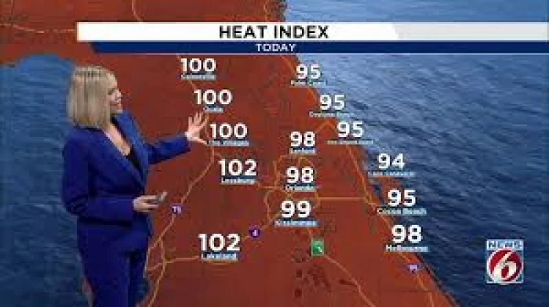
The heat will add another layer. Heat index values are expected to top 100 degrees in many areas by Friday, then push into the 100 to 105 degree range or higher this weekend and into next week. Warm nights in the 70s are expected to offer little relief, while a strengthening Atlantic ridge keeps a steady flow of moisture in place and helps trigger daily rounds of showers and thunderstorms. Rain chances are expected to stay elevated at generally 60% to 70% each day, and a moderate to major heat risk could affect portions of Central Florida. Beachgoers also need to watch the water, where a moderate risk of rip currents continues.
For Orlando and the rest of Central Florida, the next few days are shaping up as a shift from scattered Wednesday showers to a wetter, hotter stretch that lingers into early next week. The biggest unanswered question is where the slowest-moving storms will line up over the weekend, because that will decide who gets the heaviest rain and the most dangerous heat.